Arriving at Incheon International Airport and opening Google Maps to find your hotel is often the first shock for international travelers visiting South Korea. You quickly realize that walking directions are completely unavailable, public transit routes are often outdated, and driving directions don’t work at all. Don’t worry—you don’t have to get lost! In this complete guide, we will break down why Google Maps has limitations in Korea and provide a step-by-step tutorial on how to navigate Korea effortlessly using Naver Map and KakaoMap in English.
1. Why Doesn’t Google Maps Work in South Korea?
If you try to map a walking route from Myeongdong to Insadong on Google Maps, you will likely see the error message: “Can’t find a way there.”This is not a bug. Due to South Korean national security laws and spatial data regulations, high-precision mapping data cannot be exported to foreign servers without government approval.While Google Maps can still show basic points of interest and general subway lines, it does not support turn-by-turn walking or driving navigation. To travel smoothly in Korea, you must download local Korean navigation apps.
2. Naver Map vs. KakaoMap: Which One Should You Choose?
Both apps are widely used by locals and tourists alike, and both offer English language support. Here is a quick comparison:
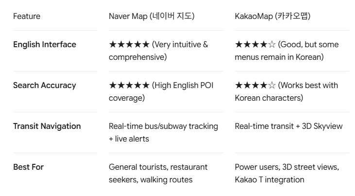
Quick Recommendation: If you are visiting Korea for the first time, Naver Map is generally the easiest and most tourist-friendly option.
3. The Ultimate Step-by-Step Guide to Naver Map (English)
Step 1: Download and Set Language to English
- Download Naver Map from the [iOS App Store] or [Google Play Store].
- Open the app. It usually detects your device language automatically.
- If it is in Korean: Tap the menu icon (☰) in the top-left corner $\rightarrow$ Settings (설정) $\rightarrow$ Language (언어) $\rightarrow$ Select English.
Step 2: How to Search Locations (The Pro Hacks)
Searching for places in English works well for major landmarks (e.g., Gyeongbokgung Palace, N Seoul Tower), but smaller cafes and restaurants might not appear with English names.
- Tip A: Search by Phone Number:Every Korean business has a unique local phone number (e.g.,
02-123-4567). Typing the phone number into Naver Map’s search bar will instantly pull up the exact venue. - Tip B: Copy & Paste Korean Names/Addresses:Keep a digital notepad with the Korean names (Hangul) of the restaurants you want to visit. Copy and paste the Korean characters for 100% search accuracy.
Step 3: Navigating Public Transit & Walking Routes
- Search your destination and tap Directions (Route).
- Choose your transport mode at the top:
- Public Transit (Bus/Subway icon): Shows the fastest subway and bus combinations, real-time arrival times, fares, and optimal subway boarding door numbers (e.g., Car 4-2 for fast transfers).
- Walking (Pedestrian icon): Provides clear step-by-step turn directions, crosswalk indicators, and elevation/stairs warnings.
Step 4: Saving Your Favorite Spots
- Tap the Bookmark (★ Save) button on any location page.
- You can organize your saved spots into custom lists (e.g., “Seoul Cafes”, “Day 1 Itinerary”, “Must-Try K-BBQ”).
4. How to Use KakaoMap (English)
KakaoMap is an excellent alternative and offers some of the best 3D panoramic views of Korean streets.
- Download & Setup: Search for KakaoMap in your app store.
- Turn on English Mode: Tap Menu (☰) $\rightarrow$ Settings $\rightarrow$ Language $\rightarrow$ English.
- Road View (Street View): Tap the camera/person icon on the right side of the screen to enter Road View. This is incredibly useful for navigating narrow alleys in areas like Ikseon-dong, Euljiro, or Hongdae.
5. 4 Essential Tips for Navigating Korea Like a Local
- Get an eSIM or Pocket Wi-Fi: Real-time navigation requires steady mobile data to track live bus arrivals and subway transfers.
- Pay Attention to Subway Exit Numbers: Korean subway stations are huge with up to 15+ exits. Navigation apps will tell you the exact exit number (e.g., Exit 3) closest to your destination. Always follow the overhead signs inside the station to your designated exit.
- Check Bus Colors:
- Blue buses: Main trunk lines connecting major districts.
- Green buses: Feeder lines connecting neighborhoods to subway stations.
- Red buses: Express commuter buses to satellite cities (Incheon, Gyeonggi-do).
- Combine with Kakao T / Uber for Taxis: If you plan on taking taxis, download Kakao T (supports international credit cards) or use your standard Uber app (which connects seamlessly to local UT taxis in Korea).
Final Thoughts
Navigating a new country without your usual navigation app can feel intimidating at first, but Naver Map and KakaoMap will make your trip to Korea smoother, faster, and much more authentic.